Friday 7/22/23
Paul was quite disappointed with the hot spring. He said it doesn’t look anything like what he saw on YouTube! (I coundn’t say “duh!”, that would have been rude right? Lol…Plus the invasion of the mosquitos was too much. We constantly have to fight them off getting in and out of the truck. The camp site was very nice, but the mosquitoes kind ruined it for us so we left the campsite and continue on our journey north.
We are now entering the Yukon, the smallest and westernmost of Canada’s three territories. It also is the second-least populated province or territory in Canada, with a population of 40,232 people as of the 2021 Census. Whitehorse, the territorial capital, is the largest settlement in any of the three territories, per Wikipedia.

And finally arrived at Watson Lake. We haven’t had a proper cell signal for days. My sister said she hasn’t seen the ETX website update since 7/14. And she’s correct. The faint signal that we do have on the road, occasionally, is only good enough to check emails or a quick text/phone call, but not enough bandwidth to update the website.
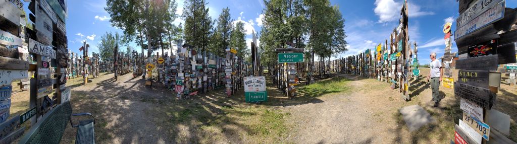
We caught up with Joe and Elfi in the parking lot of the Signpost Forest. The Sign Post Forest is a collection of signs at Watson Lake, Yukon and is one of the most famous of the landmarks along the Alaska Highway. It was started by a homesick GI in 1942 per Wikipedia. What a super cool attraction. People from all over the world stop here and put up their license plate, wood carving of their family’s name, in all shapes and fashions. It is truly a forest of signs, and a great way to share with the world. Well, we didn’t have anything to contribute but our ETX sticker, so now we can say “we were there!”

Joe pointed us to the Northern Lights museum just across the street. We paid a visit, $10 CA per person to watch a movie of how the northern lights are formed. It is such an amazing phenomenon and definitely on my bucket list. The places we are visiting from this point forward in the northerly direction are all known for the northern light sighting, except, we are here in the wrong season. Damn!!! The lightshow usually form around late fall through spring. Double Damn!!!
Did you know: An aurora, also commonly known as the polar lights, is a natural light display in Earth’s sky, predominantly seen in high-latitude regions (around the Arctic and Antarctic). Auroras display dynamic patterns of brilliant lights that appear as curtains, rays, spirals, or dynamic flickers covering the entire sky. Auroras are the result of disturbances in the magnetosphere caused by the solar wind. Aurora Borealis means “northern dawn” and was named after the Greek Goddess Aurora – goddess of the dawn.
Saturday 7/23/22 Another rest day and laundry day, website update day – thanks to the Watson Lake Visitor Center for providing this work station and data signal. From here on, we will have even more limited signal so not sure when I can update the website again. This is truly a small town since the place where we did our laundry is also a small groceries store and a small diner. Everything is super expensive here. Paul bought a 16 pack of beer for $40 CA (~ $32 USD). I told Paul he gotta knock off this habit until we reach Denali or Anchorage, Alaska!
Sunday 7/24/22
We’re traveling on the Robert Campbell Hwy today. Several overlanding bicyclists scattered on the road – looks like an organized group event I admire their will power, physical strengthr and tenacity to bike and overnight on the road, in the middle of nowhere, completely exposed to the elements .
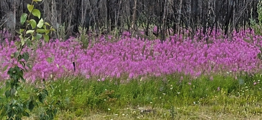
A section of the pine forest was destroyed by the wild fires, but now emerged blossoms of vibrant flowers as though Mother nature is breathing new life onto the land to make up for the losses.
While the road is not a smooth as the Alaska hwy, it is just as breathtaking with vista and big skies, green trees, wild flowers, lakes, rivers, etc. We’re told this section of the hwy will have bears so we’re on the lookout for them.
This road must be less traveled as it becomes a gravel dirt road, a bit bumpy but not bad. This road reminds me of our theme “endless trail” as it appears that the dirt trail just go on and on forever. Then out of nowhere, several rows of the pine trees have an orange- brown color as though autumn has arrived. We don’t know whether this is from the heat damage from the fire or beetles rot.
150 miles later on the same gravel road. Wow the scenery is still nice, I’m getting mental and physical exhaustion. Sitting inside the truck looking out is like playing a video game, watching the same scene over and over again for 5 hours. Just when I was about to lose it, we were able to exit to get on the road where Joe had sent us a pin to camp by Ross River. Luckily we had a bit of a cell signal and was able to find the spot. It is a beautiful camping spot right next to the lake, and very few mosquitoes. Now I can relax a bit more.
Monday 7/25/22
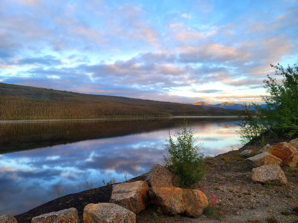
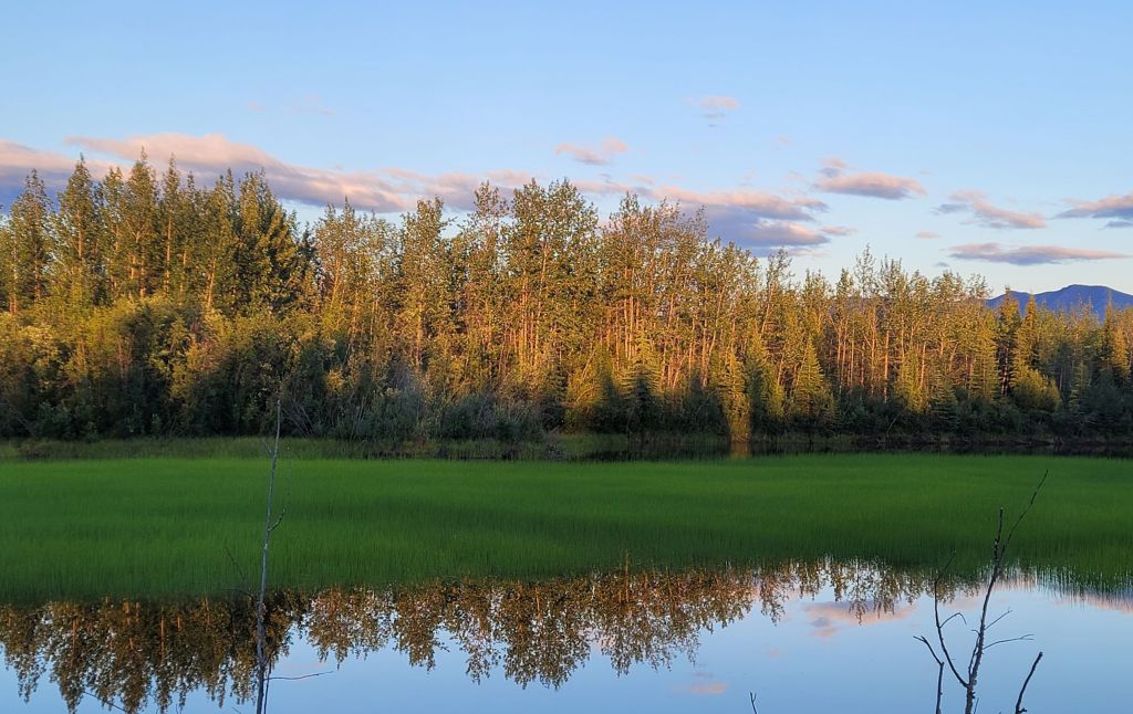
I woke up at 5:30 AM to use the restroom. Paul was already up making his coffee. I looked out the window and caught a gorgeous sunrise on the lake. The morning glory graced the lake with a little mist on the water, colorful clouds casting their reflection on the lake. I snapped a few pic from my bedroom window, too sleepy to go outside to capture the true essence of this silence and graceful view.
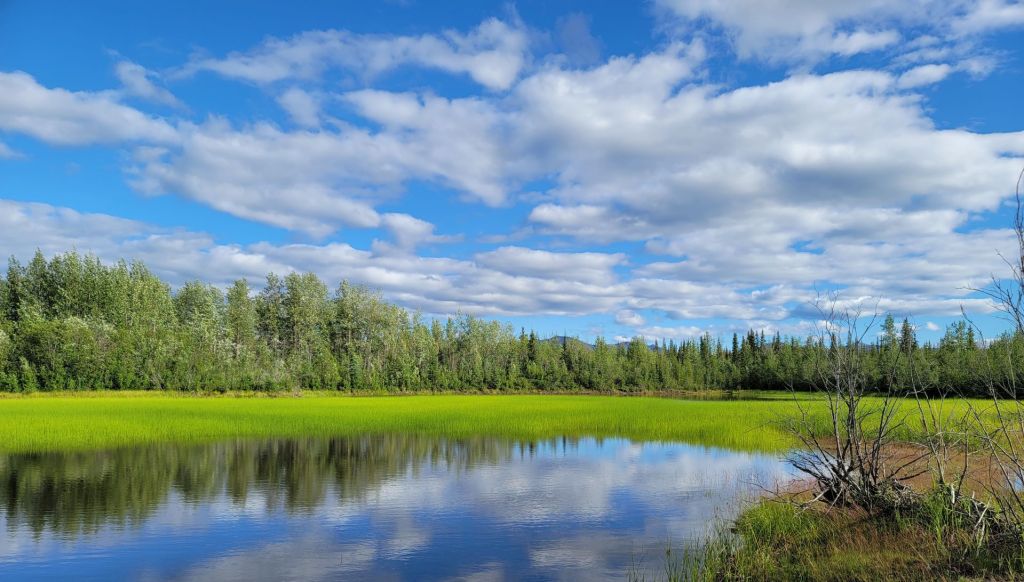
We’re traveling on hwy 2 today. So many lakes, rivers, mirror lakes, valleys, meadows with lush green everywhere. I’m definitively in a better mood today after a decent rest overnight. We’ve finally realized we need a decent break on the road to feed ourselves with some snacks, and to break up the miles so we aren’t so exhausted when a we get to destination like these past few weeks.
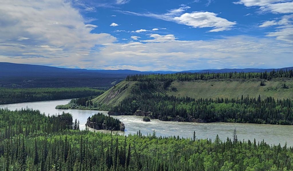
We also stopped by the Five Finger Rapid along the Yukon river, a tourist viewpoint attraction.
Camped at Pelly River Crossing campground . Caught up with Joe and Elfi.
Tuesday 7/26/22
Visited Mayo village, the heart of Yukon, a small mining town during the gold rush era . There, the main attraction was the Binet House Interpretive Centre – a small museum. Visitors can view displays about permafrost, geology and gold & silver mining in the Mayo district, and a bit of history about the Mayo residents, with a small population of about 400 people.
Camped at McIntyre Park Campround. We parked along the river banks, very pleasant camping spot with no mosquitoes. Paul finally convinced me to go for a walk as the weather is very pleasant outside. Five minutes into the open trail, we saw a dark shadow running out of the bush and Paul screamed “bear, run!” We started running towards our campsite, but then I paused and said “I thought we’re not supposed to run, but slowly back away?!” So we stopped running, and slowly back away. Meanwhile, the bear stood right in the middle of the trail, turned around , paused and stared at us. No contest Baloo, you win! !We retreated back to the home base and locked up. So much for the walk…

Wednesday 7/27/22
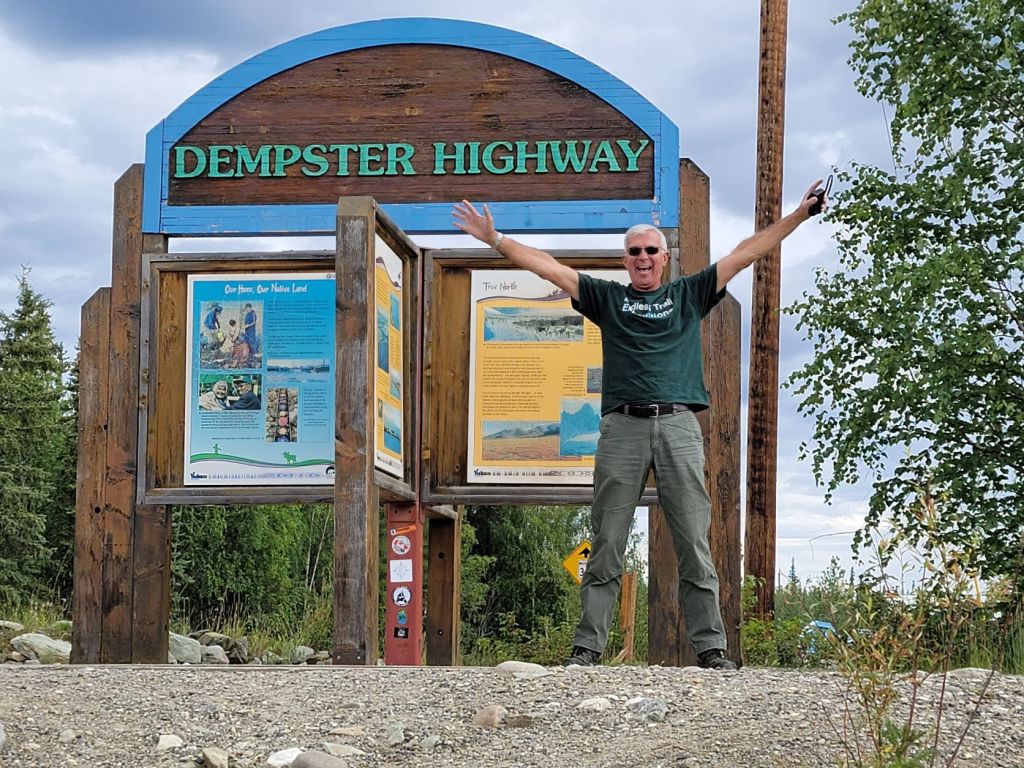
Back on hwy 2 heading towards the Dempster hwy today. Lots of constructions to repair the road. We typically had to stop and wait for about 15-20 minutes until a pilot car comes around to lead the way. We lost several hours of commuting today because of multiple construction sites. Obviously, the construction activities can only take place in the summer due to the severe weather almost year round. And finally we reached the Dempster highway.
Excerpt from the Dempster billboard:
“The Dempster Highway travels through mountains that have never seen a glacler… across rolling tundrawhere the great Porcupine Caribou Herd winters…along the trails used by native people and the North-West Mounted Police… through the land of the Gwich’in to the land of the Inuvialuit… until it reaches Inuvik – gateway to the Western Arctic. The Dempster is the only public highway in North America that crosses the Arctic Circle; beyond this point is a world that many of you have never seen.” The length of Dempster hwy is about ~ 548 miles.
We did not drive very far in terms of distance, but we were on the road for 5 hours due to the construction as mentioned above. We picked a gravel lot on the hwy to rest for the night. We contributed this site to iOverlander and named it “ETX Dempster Quarry” – a place called home for the night.
About 9 pm, surprisingly Joe and Elfi pulled into our campsite. Well hello again dear friends!
Thursday 7/28/22
“Contentment is when dreams and realities merge as one” – Maggie Ngo (yeah, I came up with these quotes when I lay in bed at night trying to fall asleep….
We stopped by Grizzly Lake viewpoint just to dump the trash. The parking lot has quite a few cars and everyone there is gearing up for a hike. We decided to do a hike too to get some exercise in. The hike was a 3.7 miles round-trip to the panoramic viewpoint. The billboard at the trailhead had a warning sign that this is bear country so bring bear spray or make loud noises while hiking. Hmmm…. we don’t have any bear spray…. we’ll have to take our chances.
We’ve been so inactive for the last few weeks making this hike a bit of a challenge for me. It started out pretty flat and then a constant uphill. I’m not sure if it’s a combination of high elevation and my poor aerobic condition but I started to have shortness of breath, a bit of chest pain, and then almost a blackout as everything was starting to go dark around me. I had to lean against a rock and then sat down to catch my breath, took a sip of water and waited a few minutes to regain my strength. Yes I know, you’re thinking “what a wuss!”

On the way up, we saw a young lady hiking down who had camped up there overnight by herself. Wow! No fear! Apparently this is a popular spot for backpacking and camping. Well we did make it to the viewpoint, it is picturesque with mountains and streams, luckily very few mosquitoes enabling us to enjoy the view more.

I thought Dempster hwy was just a boring dirt road but it turns out to be very grand vistas and streams in a wide open landscape. Kinda remind me of driving though Grand Teton national park. Truly magnificent. At one point Paul said it feels like driving through Switzerland.

Camped at Little Bear Lake – more like a swamp, but with lush green tranquil pond with a dramatic reflection of the blue sky and wandering clouds on the water.
There was a beaver in the swamp swimming around the small pond acting like a security guard checking out the surrounding area. Past midnight but still plenty of daylight, as I was getting ready for bed, I was about to close the shades to block the light, the beaver swam towards BAT all the way to the bank, looking quite suspicious. As though he saw me watching him, he swam back out. He did it a few times so I decided to “leave it to beaver…” 😉 and off to bed.
Friday 7/29/22
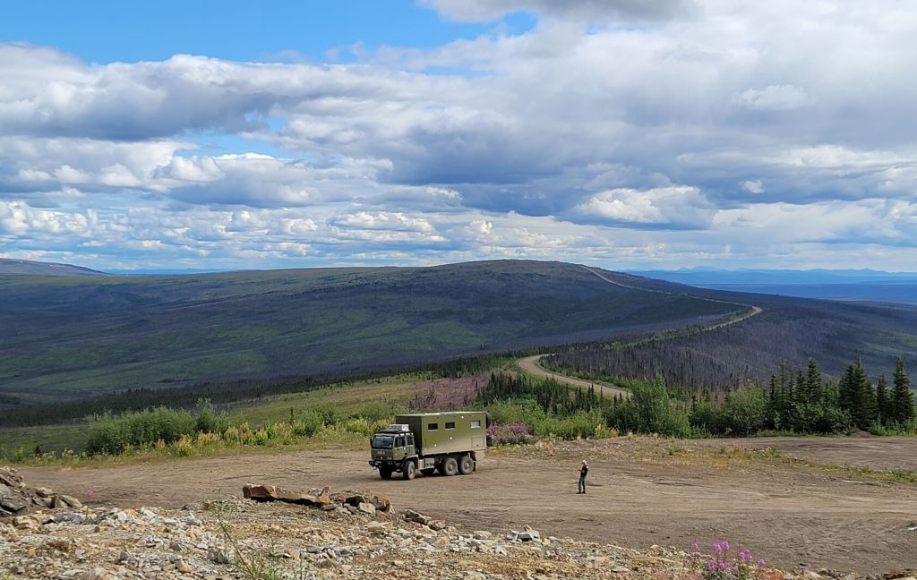
Onward to the next highlight. We pulled in to the “Top of the Hill” view point with a dramatic 360 panorama view of the valleys — what an incredible view of the Yukon. No wonder they named the Yukon “Larger than Life!!” When you’re up here looking at the world around you, you realize how small you are to this vastness of pure nature. Mother earth is truly precious. I hope this place will be here for many more generations to enjoy. I appreciate the naturalists more so everyday to have gone before us and promoted the preservation the national parks and the like in their natural environment and untamed.

We have gone off grid for almost four days now. It’s hard to be disconnected from the real world but in a way, it takes us back to the basics of life, unencumbered with all the hustle bustle of the electronic world.
But now we got desperate… We arrived at Eagles Plain and paid $5 CA per person at the only restaurant in town to get a wifi signal to check in with families, update email etc. Who knew wifi is such a hot commodity in this remote wilderness area.
And finally, we’ve reached a major milestone after thousands of miles on the road: the Arctic Circle marker, woohoo!. We did the typical tourists thing, taking pictures and “doing the silly dance/jump to commemorate this milestone. Oh Yeah!!!

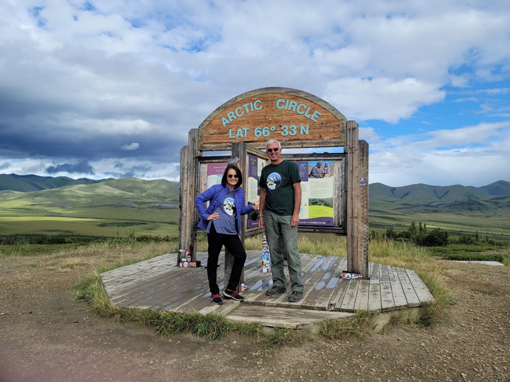
The weather turned a bit gray for the dramatic effect on we got here. We’ve been getting a little sprinkle of rain here and there causing the mosquitoes to swarm the area. We can hardly take a picture at the sign without being attacked. We’ve become the mosquitoes’ slayers. It is now part of our routine to swat them as soon as we get in the living unit when we stop to camp, and again in the morning when we get in the cab to drive off. It is such an amazing territory but quite annoying to deal with these bloodsuckers!
We just crossed the border to the Northwest Territories. Now we’re completely enveloped in a thick fog. It’s too much of a coincidence that we have been getting nice and sunny weather, then all of the sudden, as we cross the arctic circle, it rain, and as we cross into the Northwest Territories, it fogged. That’s it for today’s adventure. We seek refuge for the night on top of a hill, supposedly another 360 degree view, but the fog is so dense, we can only see a few feet in front of us so hopefully the morning will bring us pleasant surprises of the terrain.
